

ADVERTISEMENT:
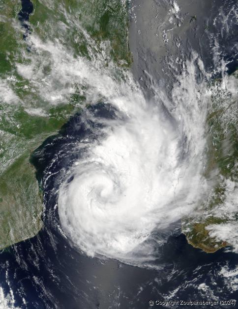
A satellite image taken by Nasa of Dineo as it was making its way to Mozambique on Tuesday, 14 February.
Wet weekend ahead
Date: 16 February 2017 By: Andries van Zyl
With tropical cyclone Dineo bearing down on the region, fears are escalating that the Soutpansberg's inhabitants might find themselves in a similar situation as during the floods caused by Cyclone Eline in 2000.
By Wednesday morning, Dineo was still classified as a severe tropical storm, positioned in the Mozambique Channel. “In the last few hours, Dineo’s track has become more ‘westerly’, with recent movement being towards the west-south-west at 7 knots (about 14 km/hr). Dineo is really living up to the notoriously fickle and unpredictable nature of such tropical systems,” said the South African Weather Service in a press release on Wednesday morning. They added that Dineo’s track began shifting overnight to adopt a more westerly trajectory, therefore departing from the mostly southwesterly track that dominated its movement on Tuesday. “The new track will take the system on to the coast early this evening, near Massinga, somewhat north of Inhambane. Moreover, Dineo is also quite likely to undergo a final surge of intensification, just before arriving over land and there is a good chance that it will reach tropical cyclone status within the next 6 to 12 hours,” said the weather service.
According to the latest prediction, Dineo would have moved overland by Thursday, 16 February, still as a significant rain-bearing system but starting to weaken considerably. Tropical systems such as Dineo, which originate over open water, are critically dependent on the open ocean as a source of latent heat energy in order to sustain their growth and intensification. The moment such systems move overland, they invariably undergo rapid structural weakening and start to decay. “Notwithstanding this, it is expected that much of southern Mozambique can expect very heavy rainfall, most likely in the region of 100 to 200mm per day (or even more). Bearing in mind that the lower portion of the Limpopo River flows directly through the Mozambican region that is most likely to be severely affected, this compounds the risk of flooding for communities which may possibly be displaced by this event,” warned the weather service.
Regarding the direct weather-related impact for South Africa, the weather service warned that heavy rainfall may occur in places over the northern lowveld and adjacent escarpment regions of Limpopo from Thursday evening, 16 February. “The greatest impact, with respect to South African provinces, is suggested to be overnight Thursday and into the morning hours of Friday, 17 February, when heavy rain can be expected over the entire eastern half of Limpopo, including the Kruger National Park, where 100 to 200mm of rain could occur per day,” said the weather service.
The service predicts that by early Friday morning, the surface vortex of Dineo should begin dissipating in the region of Musina and Beit Bridge, with its remnants expected to drift into Botswana on Saturday, 18 February. Showers are, however, expected to continue over the Limpopo Province. “Rivers in the region will continue to flow quite strongly in the latter part of the weekend and into next week, as overland runoff takes some time to enter river systems,” the service warned.
The last major cyclone to hit South African was Cyclone Eline 17 years ago and many believe South Africa is due for another massive storm. Sixteen years prior to that, many older readers will remember the devastation and loss of life caused by Cyclone Domoina in 1984. Judging by the timeframe between these cyclones, many believe the region is due for a major storm.
A lot of similarities exist between Dineo and Cyclone Eline, especially regarding timing. Eline made landfall near Beira on the Mozambiquan coast on 22 February 2000. By 27 February of that year, flash floods inundated low-lying farmland in the Xai-Xai area in Mozambique. South Africa, Botswana and Swaziland were also severely affected by Cyclone Eline, with major flooding and flood damage also in the Soutpansberg region. Mozambicans described the floods as the worst in 50 years, especially after the Limpopo River burst its banks after three weeks of heavy rain. Eline finally dissipated over eastern Namibia on 29 February 2000. By that time, Eline had travelled 11 000km in 29 days after starting as a tropical low on 1 February just south of Indonesia.
Mr Fanie Havinga, chairman of the Soutpansberg District Agricultural Union, stated on Wednesday that he did not think Dineo would have a major impact on the region. “At this stage I am not too worried about Dineo as it will not move as far inland. What it will bring is more rain, but not the damage that accompanied Cyclone Eline,” Havinga said. He was, however, hesitant regarding wind damage. “If Dineo brought along strong winds, then we would suffer major damage to our fruit trees, as well as possible long-term power outages to the Levubu area. But we will have to wait and see,” said Havinga.
Viewed: 1122
|
|
Tweet |
 |

-

MMSEZ now also looking at nuclear power
19 April 2024 By Andries van Zyl -

Woede ná R524 nog ‘n lewe eis
19 April 2024 By Andries van Zyl -

T20-spanne hervat liga ná kort breek
19 April 2024 By Andries van Zyl -

Vrae oor waarom Vhembe so sloer?
18 April 2024 By Andries van Zyl -

Border fence contractors lose appeal
18 April 2024

Andries van Zyl
Andries joined the Zoutpansberger and Limpopo Mirror in April 1993 as a darkroom assistant. Within a couple of months he moved over to the production side of the newspaper and eventually doubled as a reporter. In 1995 he left the newspaper group and travelled overseas for a couple of months. In 1996, Andries rejoined the Zoutpansberger as a reporter. In August 2002, he was appointed as News Editor of the Zoutpansberger, a position he holds until today.
More photos...

Up until Tuesday, Dineo was expected to make landfall at Inhambane in Mozambique, tracking in a westerly direction over southern Africa. By Wednesday morning, however, it was predicted that Dineo would make landfall near Massinga, somewhat north of Inhambane.
ADVERTISEMENT

-

Park development leaves residents puzzled
22 March 2024 By Andries van Zyl -

Local para-athletes shine at SA Champs
05 April 2024 -

Former Triegie’s acting career taking off
12 April 2024 By Karla van Zyl -

Epic finish for local cycling duo
29 March 2024 By Andries van Zyl -

What next Vhembe!
22 March 2024 By Andries van Zyl
ADVERTISEMENT:

ADVERTISEMENT